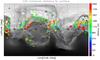
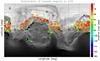
Fig. 1

Geometrical parameters of the VIRTIS-H LOS (LOS) from MTP010 to MTP012. A) Minimum distance of the LOS to the nucleus surface (in meters with the color scale given to the right); B) solar incidence angle (in degrees, with the color scale given to the right) of the closest point to the LOS. Each cross corresponds to a single 6 s acquisition. Only one in every four acquisitions is considered. The gray background represents the effective latitude based on the SHAP5 model composed of 300 000 facets to show the location of topographic features.
Current usage metrics show cumulative count of Article Views (full-text article views including HTML views, PDF and ePub downloads, according to the available data) and Abstracts Views on Vision4Press platform.
Data correspond to usage on the plateform after 2015. The current usage metrics is available 48-96 hours after online publication and is updated daily on week days.
Initial download of the metrics may take a while.