


Fig. 1
Download original image
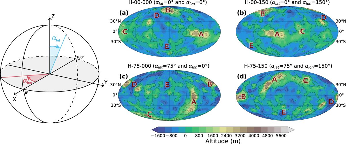
Creation of synthetic topography fields using rotations of Venus’ current topography. Left: illustration of the angles, αlat and αlon, that define the reorientation applied on the topography. The angle αlat defines the latitude of the geographic pole with respect to the rotational axis. The angle αlon defines the position of the 0° longitude relative to its present-day position. The present-day topography is therefore given by αlat = 0° and αlon = 0°. Right: topographic maps for several configurations. (a) αlat = 0° and αlon = 0° (current topography). (b) αlat = 0° and αlon = 150°. (c) αlat = 75° and αlon = 0°. (d) αlat = 75° and αlon = 150°. The transition from (a) to (b) correspond to a variation in αlon resulting in a longitudinal rotation of the topography. The transition from (a) to (c) correspond to a variation in the αlat angle resulting in a latitudinal rotation. The transition from (a) to (d) represents a combined variation in both angles. Letter A–E indicate the locations of the principal provinces of Venus, with A=A phrodite Terra, B=Ishtar Terra, C=Alta Regio, D=Guinevere Planitia, and E=Lavinia Planitia.
Current usage metrics show cumulative count of Article Views (full-text article views including HTML views, PDF and ePub downloads, according to the available data) and Abstracts Views on Vision4Press platform.
Data correspond to usage on the plateform after 2015. The current usage metrics is available 48-96 hours after online publication and is updated daily on week days.
Initial download of the metrics may take a while.