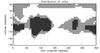
Fig. 6

Top: adopted Pluto units for modeling (white = N2, gray = CH4, black = H2O/tholin). Bottom: map of Pluto created from images taken from June 27 to July 3 by the Long Range Reconnaissance Imager (LORRI) on New Horizons, combined with lower resolution color data from the spacecraft’s Ralph instrument7. Cthulhu Regio is the dark region covering ~30°E-160°E longitudes. Sputnik Planum is the southern part of the bright region immediately to the east (informal names are taken from Stern et al. 2015).
Current usage metrics show cumulative count of Article Views (full-text article views including HTML views, PDF and ePub downloads, according to the available data) and Abstracts Views on Vision4Press platform.
Data correspond to usage on the plateform after 2015. The current usage metrics is available 48-96 hours after online publication and is updated daily on week days.
Initial download of the metrics may take a while.