Fig. 1
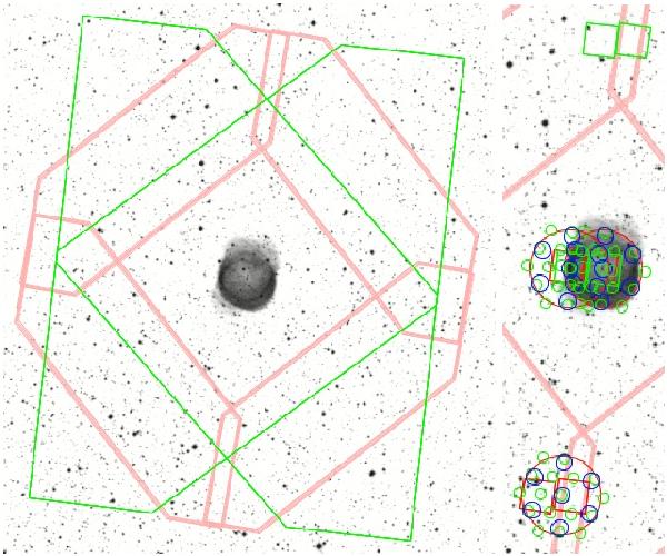
HerPlaNS spatial coverage of NGC 6781. The footprint of each instrument/observing mode is overlaid with the Digitized Sky Survey POSS2 Red map. (Left) Broadband imaging: (1) PACS scan-mapping − each pink polygon corresponds to a single medium-speed scan, delineating the four sides of the total 8′ × 8′ region of mapping, (2) SPIRE scan-mapping − each green polygon corresponds to a single scan; two orthogonal scans define the total coverage. (Right) Spectroscopy (blow-up of the central region): (3) PACS spectroscopy − a pair of red/green squares, each corresponding to chop/nod exposures (about  away in the N and S) of the 5 × 5 IFU field of 47′′ × 47′′, pointed at the center and eastern rim of the nebula, (4) SPIRE spectroscopy − groups of green/blue/red circles, each corresponding to a detector feedhorn of the SSW and SLW bands and the unvignetted 2.́6 field of view of the FTS bolometer array pointed at the same target locations as the PACS spectroscopy apertures with one off-source pointing in the S.

Current usage metrics show cumulative count of Article Views (full-text article views including HTML views, PDF and ePub downloads, according to the available data) and Abstracts Views on Vision4Press platform.
Data correspond to usage on the plateform after 2015. The current usage metrics is available 48-96 hours after online publication and is updated daily on week days.
Initial download of the metrics may take a while.