Fig. 1
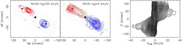
Structure of the HH 114 MMS outflow from CO(2–1) data. Left: maps of intensity integrated in velocity ranges symmetrically separated from the ambient cloud velocity (V0 = −0.5 km s-1 from N2H+ data). First contour and contour interval are 1 K km s-1 in the high-velocity map and 5 K km s-1 in the low-velocity map. The star symbol at the offset origin represents the position of HH 114 MMS ( δ(J2000) = + 7°12′2′′), the two squares are the positions where the line survey was carried out, and the dots are observed positions. The dashed green line is the direction of the position–velocity diagram shown in the next panel. Right: position–velocity diagram along the outflow axis. To emphasize the low-level outflow emission, the contours are spaced by factors of square root of 2 starting at 0.1 K.
Current usage metrics show cumulative count of Article Views (full-text article views including HTML views, PDF and ePub downloads, according to the available data) and Abstracts Views on Vision4Press platform.
Data correspond to usage on the plateform after 2015. The current usage metrics is available 48-96 hours after online publication and is updated daily on week days.
Initial download of the metrics may take a while.