Up: FIRBACK: III. Catalog, source ISOsurvey
Subsections
4 Source extraction, simulations
An important part of the present
work is the extraction of the sources, the simulation of point source observations and the analyses
of noise. After detecting sources on a median-filtered-like map, we measure the fluxes on the
final maps with aperture photometry. Our simulation tool validates the flux determination as well
as the noise analysis.
Our original maps are dominated by the fluctuations of the background
at 170  m, at all spatial scales, mainly due to the cirrus
confusion noise and the CIB fluctuations (Lagache & Puget 2000). Because of this, classical
extraction algorithms based on thresholding and local
background determination mostly fail: it is not easy to use a robust
detection algorithm on maps dominated by structures at all scales. On
the contrary, flat background maps allow reliable detection with
the available processing techniques, like Gaussian fitting methods,
e.g. for faint ISOCAM sources by Désert et al. (1999). Because of the
undersampling of the PHT Point Spread Function together with a highly
fluctuating background, CLEAN-like methods (Hogbom 1974) are
difficult to use. Wavelet decomposition, e.g. for ISOCAM by
Starck et al. (1999), is not easily implementable because of the poor spatial
dynamics of our maps ("big pixels and small maps'').
To overcome these difficulties we have developed the following method by
combining some well-known techniques for source extraction and flux
determination:
m, at all spatial scales, mainly due to the cirrus
confusion noise and the CIB fluctuations (Lagache & Puget 2000). Because of this, classical
extraction algorithms based on thresholding and local
background determination mostly fail: it is not easy to use a robust
detection algorithm on maps dominated by structures at all scales. On
the contrary, flat background maps allow reliable detection with
the available processing techniques, like Gaussian fitting methods,
e.g. for faint ISOCAM sources by Désert et al. (1999). Because of the
undersampling of the PHT Point Spread Function together with a highly
fluctuating background, CLEAN-like methods (Hogbom 1974) are
difficult to use. Wavelet decomposition, e.g. for ISOCAM by
Starck et al. (1999), is not easily implementable because of the poor spatial
dynamics of our maps ("big pixels and small maps'').
To overcome these difficulties we have developed the following method by
combining some well-known techniques for source extraction and flux
determination:
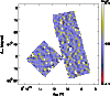 |
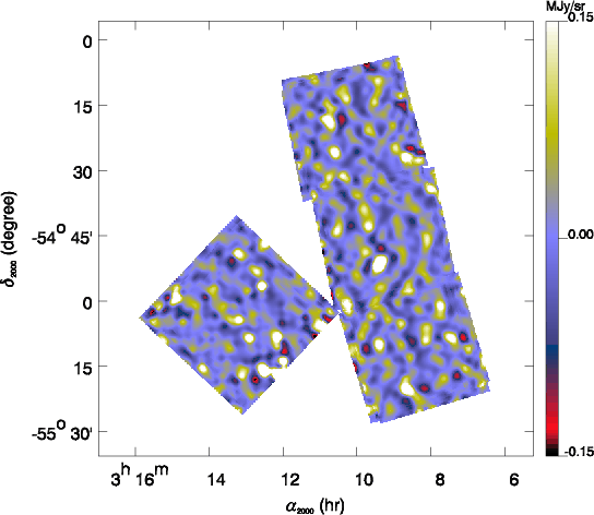
Figure 2:
Example
of a source map for source detection in the FSM
field. Background is subtracted using a
median filter in the time space (AAP). Data with only high spatial
frequencies are then reprojected on a map
with the FIRBACK pipeline. |

- background is subtracted in the one dimensional time
data (AAP level, brightness as a function of time) using a
median filter (size: 5 positions) to create source time data;
-
- source time data are processed to create 2-dimensional source maps
(Fig. 2) through the FIRBACK pipeline as decribed
in Sect. 3;
-
- source detection is performed on the source
maps using SExtractor (Bertin & Arnouts 1996);
-
- flux measurements are performed on the unfiltered maps,
using aperture photometry at the positions found by the source
detection only if there are at least 4 different observations,
and make a temporary version of the source catalog;
-
- by subtracting iteratively the brightest sources from the
temporary catalog using a CLEAN-like method on the final maps, we
remeasure with better accuracy the flux of the sources which have bright neighbours. This gives
the final catalog after two more corrections: short term transient of 10%,
and flux offset of about 15% derived from simultation (see Sect. 5).
Source detection is performed using SExtractor version 2.1.0 on the source maps with the
parameters given in Table 3. Note that we do not use the background
estimator and set it to a constant value because source maps are flat maps containing
fluctuations due to resolved sources, since the background has been filtered.
Only the positions in the map of the detected sources will be used in
the output catalog computed by SExtractor (e.g. not the flux). We discard the edges by considering only
parts of the sky that have been observed at least 4 times. This reduces the total area by about 5%.
Table 3:
Parameters used in SExtractor 2.1.0 applied on the Source Maps.
| Parameter |
Value |
DETECT_MINAREA |
10 |
DETECT_THRESH |
3.0 |
BACK_SIZE |
10 |
BACK_FILTERSIZE |
1,1 |
BACK_TYPE |
MANUAL |
BACK_VALUE |
-0.04,0.0 |
We have developed a simulation tool of point sources in order to validate the flux determinations
and study source completeness of our survey. Kawara et al. (1998) did not make such simulations and
Juvela et al. (2000) only tested the significance of their source detection because of a lack of redundancy
in their observations.
The work of Efstathiou et al. (2000) included large simulations at 90 m, but the source detection is performed by eye.
Thanks to the quiet behaviour of the C200 camera at 170 m, together with redundancy,
the detector noise as well as effects induced by
glitches can be neglected to first order with respect to the confusion
noise. (This is unlike conditions applying to the C100 camera
(Linden-Vornle et al. 2000).)
Here, we present a summary of our simulation process, followed by some details concerning the
addition of the sources and the validation:
-
- select a random sky position for a simulated source inside a FIRBACKfield;
-
- add the source in each raster in AAP level which has observed the source itself
or its wings;
-
- process maps through the FIRBACKpipeline;
-
- extract sources with SExtractor;
-
- identify the extracted sources by comparing the
coordinates with the input catalog;
-
- compute a flux with aperture photometry using the effective footprint
(defined in Sect. 5.1);
-
- validate on different flat backgrounds;
-
- validate on real data: different input fluxes and positions.
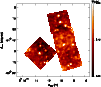 |
Figure 3:
Example of the addition
of 500 mJy sources in the FSM field. There are 8 sources spread
randomly throughout the field. One example is near the center of the
eastern survey square (FSM1). |
We use the best footprint available for PHT at 170 m (Lagache & Dole 2001) to simulate a
source with a known input flux; its spatial extension is taken to be a five pixel square, that is
about
 (note that the PIA footprint profile given in the calibration files extends
to only 4.2 arcminutes). This simulated source is added in the one dimensional time data (AAP
level). To avoid biases due to specific positions in the fields, we select random positions.
(note that the PIA footprint profile given in the calibration files extends
to only 4.2 arcminutes). This simulated source is added in the one dimensional time data (AAP
level). To avoid biases due to specific positions in the fields, we select random positions.
Because we have either 2 or 4 different raster observations of the
same parts of the sky, the randomly-selected sky position may fall e.g. on the edge
of a pixel in one raster, and at the center of another pixel in another
raster. We thus make the following approximation: we cut each PHT
pixel in 9 square sub-pixels of about
 square
arcseconds. We compute the pixelized footprint for the nine
configurations corresponding to the cases where the source center
falls on one of the sub-pixels.
square
arcseconds. We compute the pixelized footprint for the nine
configurations corresponding to the cases where the source center
falls on one of the sub-pixels.
We make separate realizations for 8 input fluxes (100,
150, 200, 300, 500, 650, 800 and 1000 mJy) and create maps using the
FIRBACKpipeline. We add only between 6 and 20 sources per square degree at a time
depending on their flux, in order to avoid changing the confusion level when sources are added in the
data. We compute the needed number of maps to get 1200 realizations
for each flux in each field, or 28800 sources in total, in order to
have a statistically significant sample. We finally get about
 different simulated maps per field (1 final map + 1
source map for each realization) taking about 14 Gbyte, after about
one week of computation under IDL on a MIPS R12000 at 300MHz SGI.
Figure 3 shows an example of added sources.
different simulated maps per field (1 final map + 1
source map for each realization) taking about 14 Gbyte, after about
one week of computation under IDL on a MIPS R12000 at 300MHz SGI.
Figure 3 shows an example of added sources.
We extract sources on the final maps and compute fluxes as explained below by aperture
photometry. The aperture photometry filter parameters have been
optimized to obtain the best signal to noise ratio using the simulations.
The validation is performed on flat background maps with different
surface brightness values (0.01, 3 and 10 MJy/sr), to check that the recovered flux
does not depend on the background. The difference between the input
and recovered flux is less than 1% on an individual raster when the
source is centered on a pixel. When using random positions of the
sources and 2 or 4 rasters co-added, the recovered fluxes
have a dispersion explained by the "edge effect'' (due to the
dilution of the flux in other pixels when the source falls on the
edge of a pixel)
and by the poor sampling of the sky, leading to an
overall uncertainty of 10%.
Up: FIRBACK: III. Catalog, source ISOsurvey
Copyright ESO 2001