A&A 379, 740-754 (2001)
DOI: 10.1051/0004-6361:20011341
S. Arnouts1 - B. Vandame1 - C. Benoist2 - M. A. T. Groenewegen1 - L. da Costa 1 - M. Schirmer 3 - R. P. Mignani 1 - R. Slijkhuis 1 - E. Hatziminaoglou 1 - R. Hook 1 - R. Madejsky 1,4 - C. Rité 5 - A. Wicenec 1
1 -
European Southern Observatory, Karl-Schwarzschild-Str. 2, 85748
Garching b. München, Germany
2 - Observatoire de la Côte d'Azur, BP 229, 06304 Nice
Cedex 4, France
3 - Max-Planck-Institut für Astrophysik, Karl-Schwarzschild-Str. 1, 85748 Garching b.
München, Germany
4 - Universidade Estadual de Feira de Santana, Campus Universitário,
Feira de Santana, BA, Brazil
5 - Observatório Nacional, Rua Gen. José Cristino 77, Rio de
Janerio, Brasil
Received 5 March 2001 / Accepted 17 September 2001
Abstract
This paper presents multi-passband optical data obtained
from observations of the Chandra Deep Field South (CDF-S), located at
![]() ,
,
![]() .
The
observations were conducted at the ESO/MPG 2.2 m telescope at La Silla
using the
.
The
observations were conducted at the ESO/MPG 2.2 m telescope at La Silla
using the
![]() Wide-Field Imager (WFI). This data set, taken
over a period of one year, represents the first field to be completed
by the ongoing Deep Public Survey (DPS) being carried out as a part of the ESO
Imaging Survey (EIS) project. This paper describes the optical
observations, the techniques employed for un-supervised pipeline
processing and the general characteristics of the final data
set. Image processing has been performed using multi-resolution image
decomposition techniques adapted to the EIS pipeline. The automatic
processing steps include standard de-bias and flat-field, automatic
removal of satellite tracks, de-fringing/sky-subtraction, image
stacking/mosaicking and astrometry. Stacking of dithered images is
carried out using pixel-based astrometry which enables the efficient
removal of cosmic rays and image defects, yielding remarkably clean
final images. The final astrometric calibration is based on a
pre-release of the GSC-II catalog and has an estimated intrinsic
accuracy of
Wide-Field Imager (WFI). This data set, taken
over a period of one year, represents the first field to be completed
by the ongoing Deep Public Survey (DPS) being carried out as a part of the ESO
Imaging Survey (EIS) project. This paper describes the optical
observations, the techniques employed for un-supervised pipeline
processing and the general characteristics of the final data
set. Image processing has been performed using multi-resolution image
decomposition techniques adapted to the EIS pipeline. The automatic
processing steps include standard de-bias and flat-field, automatic
removal of satellite tracks, de-fringing/sky-subtraction, image
stacking/mosaicking and astrometry. Stacking of dithered images is
carried out using pixel-based astrometry which enables the efficient
removal of cosmic rays and image defects, yielding remarkably clean
final images. The final astrometric calibration is based on a
pre-release of the GSC-II catalog and has an estimated intrinsic
accuracy of
![]() 0.10 arcsec, with all passbands sharing the same
solution. The paper includes data taken in six different filters
(U'UBVRI). The data cover an area of about 0.25 square degrees
reaching 5
0.10 arcsec, with all passbands sharing the same
solution. The paper includes data taken in six different filters
(U'UBVRI). The data cover an area of about 0.25 square degrees
reaching 5![]() limiting magnitudes of
U'AB=26.0,
UAB=25.7,
BAB=26.4,
VAB=25.4, RAB=25.5 and IAB=24.7 mag, as measured within a
limiting magnitudes of
U'AB=26.0,
UAB=25.7,
BAB=26.4,
VAB=25.4, RAB=25.5 and IAB=24.7 mag, as measured within a
![]() aperture. The optical
data covers an area of
aperture. The optical
data covers an area of ![]() 0.1 square degrees for which moderately
deep observations in two near-infrared bands are also available,
reaching
0.1 square degrees for which moderately
deep observations in two near-infrared bands are also available,
reaching ![]() limiting magnitudes of
limiting magnitudes of
![]() and
and
![]() .
The current optical/infrared data also fully
encompass the region of the deep X-ray observations recently completed
by the Chandra telescope. The optical data presented here, as well as
the infrared data released earlier, are publicly available world-wide
in the form of fully calibrated pixel and associated weight maps and
source lists extracted in each passband. These data can be requested
through the URL "http://www.eso.org/eis''.
.
The current optical/infrared data also fully
encompass the region of the deep X-ray observations recently completed
by the Chandra telescope. The optical data presented here, as well as
the infrared data released earlier, are publicly available world-wide
in the form of fully calibrated pixel and associated weight maps and
source lists extracted in each passband. These data can be requested
through the URL "http://www.eso.org/eis''.
Key words: catalogs - surveys - stars: general - galaxies: general
The successful application of photometric techniques to identify
high-redshift galaxies (
![]() ), combined with large-aperture
telescopes with multi-object spectrographs, have provided the means to
study large-scale structures at high-redshifts and to directly probe
their evolution over a broad range of redshifts. Currently, the
challenge is to construct well-defined statistical galaxy samples at
faint magnitudes and use photometric redshift techniques to pre-select
candidates for large spectroscopic surveys probing the high-redshift
Universe. To achieve this goal, deep optical/infrared multi-passband
surveys covering areas of the order of a few degrees are required.
), combined with large-aperture
telescopes with multi-object spectrographs, have provided the means to
study large-scale structures at high-redshifts and to directly probe
their evolution over a broad range of redshifts. Currently, the
challenge is to construct well-defined statistical galaxy samples at
faint magnitudes and use photometric redshift techniques to pre-select
candidates for large spectroscopic surveys probing the high-redshift
Universe. To achieve this goal, deep optical/infrared multi-passband
surveys covering areas of the order of a few degrees are required.
Interest in this type of dataset is widespread in Europe given the
imminent commissioning of the multi-object spectrograph VIMOS, part of
the new generation of VLT instruments. Foreseeing this need, the
Working Group (WG) for public surveys at ESO recommended in early 1999
the undertaking of a deep, multi-passband, optical survey covering
three separate regions of sky one square degree each, with some areas
also covered in the infrared. These regions, referred to as Deep-1, 2
and 3, are located over a wide range of right ascension and each
corresponds to four adjacent pointings (a-d) of the Wide-Field Imager
(WFI) mounted on the 2.2 m MPG/ESO telescope at La Silla. The main goal
of the survey is to produce suitable statistical samples to study
large-scale structures in the redshift domains
![]() and
and
![]() .
Details of the position of the selected regions can be
found at the URL "http://www.eso.org/science/eis/''. One of the
selected regions includes the Chandra Deep Field South (CDF-S;
Giacconi et al. 2001) chosen because of its low column-density of
hydrogen and absence of bright stars, characteristics that make it
well-suited for deep X-ray observations with the Chandra (AXAF)
telescope. These observations have recently been completed for a total
integration time of one million seconds producing the deepest
high-resolution X-ray image ever taken (Rosati et al. 2001).
.
Details of the position of the selected regions can be
found at the URL "http://www.eso.org/science/eis/''. One of the
selected regions includes the Chandra Deep Field South (CDF-S;
Giacconi et al. 2001) chosen because of its low column-density of
hydrogen and absence of bright stars, characteristics that make it
well-suited for deep X-ray observations with the Chandra (AXAF)
telescope. These observations have recently been completed for a total
integration time of one million seconds producing the deepest
high-resolution X-ray image ever taken (Rosati et al. 2001).
In this paper, the UBVRI optical observations with the WFI of one of
the selected fields (Deep-2c), covering the CDF-S, are
presented. These data are used to make a first assessment of the
procedures and overall performance of the optical part of the Deep
Public Survey (DPS). The optical data presented here complement those
in the near-infrared covering an area of ![]() 0.11 square degrees
(Vandame et al. 2001) encompassing the region covered by the Chandra
observations. The new data reported here extend earlier
optical/infrared observations of this field carried out by EIS at the
NTT in 1998, covering a considerably smaller region. These older data
are currently being re-analyzed to produce, together with the new data,
a homogeneous dataset (Benoist et al. 2001a) which will supersede the
earlier 1998 release (Rengelink et al.
1998). Section 2 reviews the overall observing
strategy and describes the observations. Section 3
discusses the techniques employed in the data reduction and the
photometric and astrometric calibration of the images. While other
derived products are expected to be made available in the near future,
only photometric parameters of the sources detected in each of the
available passbands are presented for the moment in
Sect. 4. Even though the goal of the present paper
is not to interpret the data being released, Sect. 5
presents the results of comparisons between the present observations
and those of other authors. This is done for the sole purpose of
assessing the quality of the astrometry and photometry of the present
data set and its adequacy to meet the main goals of the
survey. Finally, a brief summary is presented in
Sect. 6.
0.11 square degrees
(Vandame et al. 2001) encompassing the region covered by the Chandra
observations. The new data reported here extend earlier
optical/infrared observations of this field carried out by EIS at the
NTT in 1998, covering a considerably smaller region. These older data
are currently being re-analyzed to produce, together with the new data,
a homogeneous dataset (Benoist et al. 2001a) which will supersede the
earlier 1998 release (Rengelink et al.
1998). Section 2 reviews the overall observing
strategy and describes the observations. Section 3
discusses the techniques employed in the data reduction and the
photometric and astrometric calibration of the images. While other
derived products are expected to be made available in the near future,
only photometric parameters of the sources detected in each of the
available passbands are presented for the moment in
Sect. 4. Even though the goal of the present paper
is not to interpret the data being released, Sect. 5
presents the results of comparisons between the present observations
and those of other authors. This is done for the sole purpose of
assessing the quality of the astrometry and photometry of the present
data set and its adequacy to meet the main goals of the
survey. Finally, a brief summary is presented in
Sect. 6.
The optical observations of the CDF-S region (
![]() ,
,
![]() )
were carried out using the WFI camera
at the Cassegrain focus of the MPG/ES0 2.2 m telescope at the La Silla
observatory. WFI is a focal reducer-type mosaic camera with
)
were carried out using the WFI camera
at the Cassegrain focus of the MPG/ES0 2.2 m telescope at the La Silla
observatory. WFI is a focal reducer-type mosaic camera with
![]() CCD chips. Each chip is composed of a
CCD chips. Each chip is composed of a
![]() pixel
array and covers a field of view of
pixel
array and covers a field of view of
![]() arcmin with a
projected pixel size of 0.238 arcsec. The 8 CCDs are physically
separated by gaps of width 23.8 and 14.3 arcsec along the right
ascension and declination directions, respectively. The full field of
view of the camera is thus
arcmin with a
projected pixel size of 0.238 arcsec. The 8 CCDs are physically
separated by gaps of width 23.8 and 14.3 arcsec along the right
ascension and declination directions, respectively. The full field of
view of the camera is thus
![]() arcmin, with a filling factor
of 95.9%. Details on the WFI layout can be found, for instance, at
the URL
"http://www.eso.org/science/eis/eis_proj/public/wfi_chip.html'' as
well as at other locations on the ESO web pages.
arcmin, with a filling factor
of 95.9%. Details on the WFI layout can be found, for instance, at
the URL
"http://www.eso.org/science/eis/eis_proj/public/wfi_chip.html'' as
well as at other locations on the ESO web pages.
Observations of the CDF-S have been performed using the WFI filters
summarized in Table 1. The U-band observations were
originally conducted using the available narrow filter which was
recently (October 2000) replaced by a broader filter to increase the
efficiency of the survey. The transmission curves of these filters
are plotted in Fig. 1 together with their final
throughputs taking into account the optics and the CCD quantum
efficiency. It is worth mentioning that very little was known about
the performance of the instrument at the time the survey was
conceived, especially at the blue and red ends of the wavelength range
considered.
| Filter | ESO id |
|
FWHM |
| (Å) | (Å) | ||
| U | U/38 | 3710 | 325 |
| U' | U 350/60 | 3538 | 560 |
| B | B/99 | 4556 | 905 |
| V | V/89 | 5342 | 900 |
| R |
|
6402 | 1595 |
| I | I c/lwp | 8535 | 1387 |
![\begin{figure}
\par\includegraphics[angle=-90,width=8.8cm,clip]{MS1242f1.ps}
\end{figure}](/articles/aa/full/2001/44/aa1242/img25.gif) |
Figure 1: Transmission curves of the filters (dashed line) and the total throughput of the system (solid line). |
| Open with DEXTER | |
The observations in each passband were split into observation blocks
(OBs) consisting of a sequence of five exposures with the integration
time for each individual exposure ranging from 5 to 15 min
depending on the passband. Table 2 summarizes the
planned observational strategy, listing: in Col. 1 the passband; in
Col. 2 the integration time of each individual exposure; in Col. 3 the number of exposures per OB; in Col. 4 the integration time
per OB; in Col. 5 the number of OBs; and in Col. 6 the planned
total integration time per band. According to the planned strategy, a
total of 210 WFI frames were required to complete a single pointing.
In order to minimize the imprint of the inter-chip gaps the choice of
pointings were done in the following way. First, the nominal position
of each OB (in a given passband) was drawn from a pre-defined list of
distinct positions, as given in Table 3. For instance,
in the case of U-band which requires 13 OBs, the dithering pattern
used is illustrated in Fig. 2. Next, each exposure
in the OB sequence was dithered relative to the OB reference position
using the offsets in right ascension (
![]() )
and
in declination (
)
and
in declination (
![]() )
as listed in Table 4
and illustrated in the inset of Fig. 2. This
dithering is essential for de-fringing as well as for efficiently
removing cosmic rays and other CCD blemishes.
)
as listed in Table 4
and illustrated in the inset of Fig. 2. This
dithering is essential for de-fringing as well as for efficiently
removing cosmic rays and other CCD blemishes.
| Filter |
|
|
|
| U | 60000 | 13 | 900 |
| B | 12000 | 8 | 300 |
| V | 9000 | 6 | 300 |
| R | 9000 | 6 | 300 |
| I | 27000 | 9 | 600 |
| ID | ||
| 01 | 03:32:28 | -27:48:47 |
| 02 | 03:32:34 | -27:48:17 |
| 03 | 03:32:36 | -27:49:02 |
| 04 | 03:32:32 | -27:49:32 |
| 05 | 03:32:23 | -27:49:17 |
| 06 | 03:32:21 | -27:48:31 |
| 07 | 03:32:25 | -27:48:02 |
| 08 | 03:32:30 | -27:47:47 |
| 09 | 03:32:27 | -27:49:47 |
| 10 | 03:32:19 | -27:50:02 |
| 11 | 03:32:38 | -27:47:32 |
| 12 | 03:32:40 | -27:50:17 |
| 13 | 03:32:17 | -27:47:17 |
| Dith. # |
|
|
| 1 | 0 | 0 |
| 2 | -70 | +21 |
| 3 | -35 | -42 |
| 4 | +35 | +42 |
| 5 | +70 | -21 |
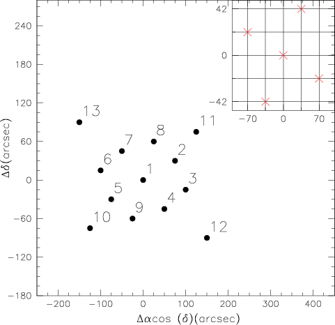 |
Figure 2: Schematic view of the dithering pattern used in the observations. Large filled circles mark the coordinates of each OB relative to the nominal center of the field (OB #1 in Table 3). Inset: the crosses mark the offset, in arcsec, of each single exposure within an OB, with respect to its center. |
| Open with DEXTER | |
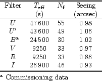
The optical observations span six observing runs over a period of one year (ESO observing periods 64 and 66), distributed over a total of 12 nights. The log of the observations is summarized in Table 5. The table lists: in Col. 1 the date of the observations; in Col. 2 the passband; in Col. 3 the integration time; and in Cols. 4 and 5 the range and average seeing during the night as measured by the seeing monitor. Not listed are the B-band observations taken during the commissioning phase of the WFI, in January 1999, and the U-band data of the COMBO survey (Wolf et al. 2001). Both data sets have been re-processed, for the sake of homogeneity, and used to produce the final combined images. Table 6 summarizes the data available for the CDF-S used in this paper. The table lists: in Col. 1 the band; in Col. 2 the total integration time; in Col. 3 the total number of frames; and in Col. 4 the average seeing of the final co-added images.
| Date | Filter | T | seeing range | mean seeing |
| (s) | (arcsec) | (arcsec) | ||
| Nov. 04 1999 | U | 11700 | 0.62-0.97 | 0.77 |
| I | 8400 | 0.77-1.71 | 1.04 | |
| Nov. 05 1999 | U | 13500 | 0.74-0.94 | 0.82 |
| Nov. 06 1999 | U | 14400 | 0.48-0.83 | 0.64 |
| Nov. 07 1999 | I | 17700 | 0.76-1.26 | 0.97 |
| Nov. 08 1999 | V | 13500 | 1.40-1.81 | 1.61 |
| I | 6000 | 1.20-2.08 | 1.64 | |
| Dec. 03 1999 | V | 6000 | 0.46-0.98 | 0.66 |
| Dec. 04 1999 | V | 3000 | 0.48-0.72 | 0.58 |
| R | 9000 | 0.47-0.79 | 0.58 | |
| I | 1800 | 0.67-0.77 | 0.71 | |
| Oct. 26 2000 |
|
13000 | 0.57-1.04 | 0.78 |
| Oct. 27 2000 |
|
11700 | 0.52-1.01 | 0.70 |
| Nov. 27 2000 |
|
9000 | 0.50-0.76 | 0.59 |
| Nov. 28 2000 |
|
9000 | 0.67-1.06 | 0.87 |
| Nov. 29 2000 |
|
4500 | 0.66-1.88 | 0.76 |
To assess the effectiveness of the adopted dithering
pattern, Fig. 3 illustrates the exposure time map
associated with the final R-band image which is an example of one of
the passbands with the shortest exposure and is thus the least
homogeneous (see Sect. 5). In this particular case,
the flux ratio of the best sampled region to that at the center of the
image is a factor ![]() 2. This is due in part to the clipping
(
2. This is due in part to the clipping
(![]() 200 pixels) of the CCD frames not taken into account in the
original design of the dithering pattern. In the weight-map the
effects of at least three satellite tracks can be seen. It is
important to point out that some of the survey data have been obtained
using dithering patterns different from the one shown in
Fig. 3 (e.g., the B-images taken during the
commissioning of WFI). In fact, during the course of the survey the
pattern has been changed at least once to improve the uniformity of
the final image.
200 pixels) of the CCD frames not taken into account in the
original design of the dithering pattern. In the weight-map the
effects of at least three satellite tracks can be seen. It is
important to point out that some of the survey data have been obtained
using dithering patterns different from the one shown in
Fig. 3 (e.g., the B-images taken during the
commissioning of WFI). In fact, during the course of the survey the
pattern has been changed at least once to improve the uniformity of
the final image.
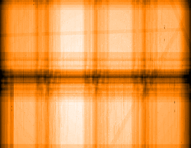 |
Figure 3: Weight map corresponding to the final co-added R-band image. The bright regions correspond to locations in the image which have higher sensitivity. While the effect of the inter-chip gaps are minimized, their imprint can still be seen and correspond to the darkest regions of the map (see text for more details). Also note the slightly lower sensitivity in regions where satellite tracks have been detected in individual frames and removed. At least two of them are clearly seen on the upper part and on the right side of the weight map, respectively. |
| Open with DEXTER | |
The present optical survey complements both recent infrared observations reported by Vandame et al. (2001) as well as optical/infrared observations conducted as part of the EIS-DEEP survey first released in 1998 (Rengelink et al. 1998) and currently under revision (Benoist et al. 2001a). The coverage of this field by these different sets of data is shown schematically in Fig. 4.
The WFI images were processed using the refurbished EIS pipeline (e.g., da Costa et al. 1999; da Costa 2001) which includes new operational modules to enable unsupervised pipeline reduction of WFI images as well as new software routines for carrying out the basic steps of image processing and calibration. Given the scope of the surveys being carried out by EIS, special attention has been given to the development of a survey software system to ensure the adequate and timely processing of large amounts of data for long periods of time in a uniform way. For instance, the complete DPS survey will consist of some 2800 WFI science frames representing over 1 Terabyte of data, to which should be added a comparable amount of data from the so-called Pre-Flames survey not discussed here (Momany et al. 2001). While a detailed account of the extent of these changes is beyond the scope of the present paper, some of the main features are briefly summarized below.
One of the main changes has been the complete removal of different
IRAF packages (e.g., xccdred, drizzle) used earlier to process images
from CCD mosaics and in the co-addition phase. Instead, WFI images are
now split into individual chips at the very beginning of the
process. The main advantages of adopting this procedure are that the
pipeline uses a common library of routines, single and multi-chip
images are treated in the same way and that the EIS pipeline is more
easily adaptable to use PC-based Linux clusters for
parallel-processing images, which will eventually lead to a higher
throughput.
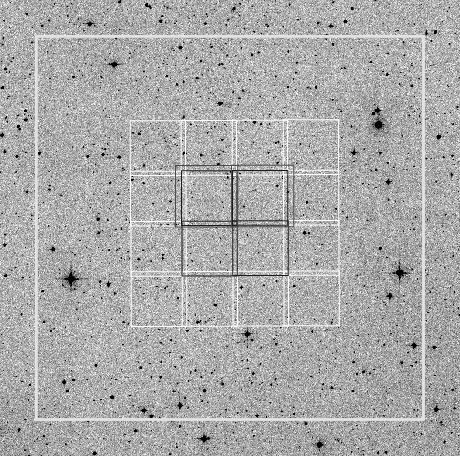 |
Figure 4:
Schematic view of the coverage of the CDF-S by the EIS
program using different instruments. The outer white box delineates the
coverage of the present optical survey (WFI). The |
| Open with DEXTER | |
A major effort has also been made to address specific problems encountered with the data files coming from WFI. These have constantly evolved, which makes them difficult to handle from the point of view of a pipeline. One of the main challenges has been the lack of information in the FITS header regarding the reference pixel. This prevented the unsupervised reduction of the WFI data due to frequent failures in the astrometric calibration from run to run. As the EIS observations with WFI span a long period of time (over two years), during which several upgrades of the data acquisition were made, it was necessary to develop robust procedures to cope with these various changes automatically.
Using tools available from the multi-resolution visual model package
(MVM) developed by Bijaoui and collaborators, a special routine was
developed to find a first-order astrometric solution for an image,
searching a large (![]()
![]() )
area surrounding the nominal
position of the pointing. The method uses one of the science frames in
the run and takes the available information in the image header
regarding the pointing only as a first guess. This image is quickly
reduced and decomposed using a wavelet transform. The lowest
resolution component is then used to cross-correlate features against
a low-resolution mock image representing the reference catalog over a
much larger area than the original image. The low-resolution science
image is then moved around in a spiral pattern starting from its
nominal position as given in the image header. At each step a
cross-correlation function between the features in the real and mock
images is computed and the process resumed. At the end of the search,
the position with the largest amplitude of the cross-correlation is
used to define a first approximation for the location of the reference
pixel for that run. This procedure is aimed at correcting only for
large shifts. A more refined astrometric calibration is performed at a
later stage.
)
area surrounding the nominal
position of the pointing. The method uses one of the science frames in
the run and takes the available information in the image header
regarding the pointing only as a first guess. This image is quickly
reduced and decomposed using a wavelet transform. The lowest
resolution component is then used to cross-correlate features against
a low-resolution mock image representing the reference catalog over a
much larger area than the original image. The low-resolution science
image is then moved around in a spiral pattern starting from its
nominal position as given in the image header. At each step a
cross-correlation function between the features in the real and mock
images is computed and the process resumed. At the end of the search,
the position with the largest amplitude of the cross-correlation is
used to define a first approximation for the location of the reference
pixel for that run. This procedure is aimed at correcting only for
large shifts. A more refined astrometric calibration is performed at a
later stage.
Another important generic routine was developed to recognize different types of exposures (calibration frames such as dome, sky flats and bias, photometric standard stars or science frames), reject bad frames and associate frames into pseudo-OBs to be reduced according to pre-defined prescriptions depending on their nature and passband. The association is based on the frame type and on the spatial separation and time interval between consecutive frames. Next, the removal of instrumental signatures such as bias subtraction, flat-fielding and de-fringing are carried out using identical procedures as those applied for infrared images as presented by Vandame et al. (2001). Some of the main features of the software worth mentioning are that the stacking of images is carried out in pixel space (see below), thereby allowing the optimal rejection of cosmic rays and bad pixels using sigma-clipping. Satellite tracks, quite frequent in wide-field images, are efficiently masked on the individual exposures using the Hough transform (Vandame 2001), thereby minimizing their impact on the final stacked image. The number of satellite tracks removed in a single passband ranges from 9 (e.g., R-band images) to 75 (U-band images) depending on the exposure time. In principle, other linear features such as diffraction spikes may also be treated in the same way. The net result of these new developments has been the production of remarkably clean final images, significantly superior to those of earlier releases. These results lead to the production of considerably more reliable source detections since the successful masking of features at the level of individual exposures dramatically minimizes the number of false detections in the final image. Finally, using the sky-flats, a first evaluation of the relative gains of the different chips is conducted for each passband, which it is later applied to the science frames. These relative gains vary from passband to passband and are, in some cases, especially in the UV, as large as 10%.
The stacking of the images is done in two distinct steps. First, the five images belonging to the same OB are warped to the first image of the OB, which is used as reference for the pixel based relative astrometry. All the images in the OB are then averaged. The second step involves warping all the co-added images corresponding to each OB to an absolute astrometric reference catalog (see next section). The resulting images are then co-added taking into account their respective weight-maps, noise and flux scales. For this particular data set the warping of the images has been performed using the nearest-neighbor approach. The advantage of this warping is that the noise of the final image is uncorrelated. However, the astrometric solution is less precise due to discreteness effects. A new version of the warping has been developed allowing for a suite of kernel functions.
In contrast to other instruments (e.g., FORS), the fringing observed in
I-band with WFI has a peak-to-peak amplitude of ![]() 10% relative
to the background and varies on scales of hours. The de-fringing is
performed in exactly the same way as for the infrared images, except
that the number of frames in an OB is considerably smaller, making a
good estimate harder. Currently, the residual contribution after
de-fringing is comparable to the image noise. However, as in the case
of the infrared, it would be preferable to decrease the integration
time of each exposure and increase the number of dithered
images. Based on the current findings, future I-band observations
will be done using a different observing strategy.
10% relative
to the background and varies on scales of hours. The de-fringing is
performed in exactly the same way as for the infrared images, except
that the number of frames in an OB is considerably smaller, making a
good estimate harder. Currently, the residual contribution after
de-fringing is comparable to the image noise. However, as in the case
of the infrared, it would be preferable to decrease the integration
time of each exposure and increase the number of dithered
images. Based on the current findings, future I-band observations
will be done using a different observing strategy.
The implementations described above make the EIS pipeline a tool capable of handling data from different telescope/instrument setups with different implementations of the FITS header. Finally, it is worth pointing out that using the available software several new developments are planned for the future. These include seeing deconvolution, morphological classification and difference image photometry for variability studies.
The astrometric calibration of the images was performed using as the reference catalog a pre-release version of the Guide Star Catalog-II (GSC-II). The GSC-II (McLean et al. 2001) is based on multi-passbands all-sky photographic plate surveys including the Palomar Observatory Sky Survey (POSS-I-II), the SERC and the ESO Red Survey. The astrometric calibration of GSC-II has been obtained relative to Hipparcos (Perryman et al. 1997) and Tycho catalogs (Høg et al. 1997) and the ACT (Urban et al. 1998). The astrometric calibration was done using the method developed by Djamdji et al. (1993) based on a multi-resolution decomposition of images using wavelet transforms (MVM). An implementation of these algorithms to stack images, referred to as MVM-astrometry, has been done for EIS as is described above. This package has proven to be efficient and robust for pipeline reductions.
Magnitudes were calibrated to the Johnson-Cousins system using Landolt standards taken from Landolt (1992). While standard stars were observed on every night, to optimize the observing time most observations were used to monitor the zero-point of the night and to compute color terms. For the final calibration, three nights in October 2000, all photometric, were used to obtain measurements of standards over a broad range of airmasses. During these nights, a set of dithered images in each passband was taken overlapping two adjacent pointings (Deep2-b and Deep-2c). These were then used to set the absolute flux scale for all passbands, except the I-band due to problems with de-fringing. For this case, the night of Nov. 4 1999 was used to determine the I-band calibration.
Photometric solutions were obtained using the new EIS photometric pipeline which is fully integrated to the associated database. The tool provides a convenient environment to obtain, verify and store the results of the fits. In the interactive mode it is possible to fit the data after rejecting individual measurements, stars and chips. Alternatively, one can also easily obtain independent solutions for each chip. Unfortunately, the number of standards for the fields considered does not allow independent solutions for each of the eight chips. Therefore, the present calibration had to rely on solutions including all the available chips.
Magnitudes for Landolt stars were obtained using an aperture 6 arcsec
in diameter, which proved to be adequate by monitoring the growth
curve of all the measured stars. The accuracy of the zero-points are
estimated to be in the range ![]() 0.03 mag to
0.03 mag to ![]() 0.08 mag, with the
U-bands having the largest uncertainties. At face value, these
results indicate that the gain correction applied to the different
chips based on the flatfield exposures is adequate for most passbands
with the possible exception of the U-band. A final determination of
the relative gains will require a more careful monitoring of the
amplitude of these corrections and chip-based solutions. A set of
secondary stars for all the Landolt fields considered would also be
extremely useful to always allow a chip-based calibration. Efforts in
this direction are already underway by several groups.
0.08 mag, with the
U-bands having the largest uncertainties. At face value, these
results indicate that the gain correction applied to the different
chips based on the flatfield exposures is adequate for most passbands
with the possible exception of the U-band. A final determination of
the relative gains will require a more careful monitoring of the
amplitude of these corrections and chip-based solutions. A set of
secondary stars for all the Landolt fields considered would also be
extremely useful to always allow a chip-based calibration. Efforts in
this direction are already underway by several groups.
The computed extinction coefficients compare well with those estimated
from the mean extinction curve of the Chilean sites. Finally, the
following color terms, relative to the Johnson-Cousins (JC) system,
have been empirically determined:
| = | |||
| = | |||
| = | |||
| = | |||
| = | |||
| = | |||
| = | |||
| = | |||
| = |
| = | |||
| = | |||
| = | |||
| = | |||
| = | |||
| = |
The magnitudes were also corrected for galactic absorption, using E(B-V)=0.0089 as derived from Schlegel et al. (1998), yielding AU=0.05 mag, AB=0.04 mag, AV=0.03 mag, AR=0.02 mag and AI=0.02 mag. All magnitudes have been converted to the AB system, unless otherwise specified, using the following relations: U'AB = U' + 1.04; UAB = U + 0.80; BAB= B - 0.11; VAB= V; RAB= R + 0.19; and IAB=I + 0.50.
The images being released are fully astrometrically (conical equal-area projection; COE) and photometrically calibrated (normalized to 1 s exposure time). The FITS files being provided include both the pixel and weight maps as FITS extensions. A stand-alone software tool to convert the COE images to best-fit TAN projection by modifying the image headers is available through the EIS web pages. The astrometric information is stored in the world coordinate system (WCS) keywords in the FITS headers. Similarly, the photometric calibration is provided by the zero-point and its error available in the header keywords ZP and ZP_ERR. The zero-point includes the normalized zero-point of the photometric solution and the atmospheric extinction correction. In the header one can also find a product identification number (P_ID) which should always be used as reference. The headers also provide information on the number of stacked frames and the on-source total integration time. Additionally, the seeing obtained by measuring the FWHM of bright stars in the final stacked images is stored in the header keyword SEE_IMA.
High-resolution images in the different passbands can be found at the
URL "http://www.eso.org/science/eis/''. The image qua- lity of the
final images can be assessed by investigating the nature and the
amplitude of the PSF distortions. These are measured by using the two
components of the so-called polarization vector. These components are
derived from the major- (A) and minor-axis (B) and the position angle
(![]() )
as measured by SExtractor for point-like sources using the
following expressions:
)
as measured by SExtractor for point-like sources using the
following expressions:
| e1 = |
|
| e2 = |
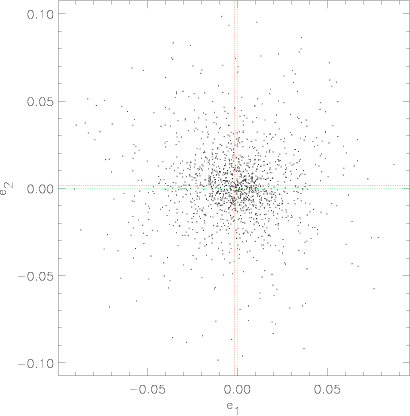 |
Figure 5: Amplitude of the PSF distortion over the entire final R-band image. One line is centered on (0, 0), the other on the actual barycenter of the datapoints on (-0.002, 0.002). |
| Open with DEXTER | |
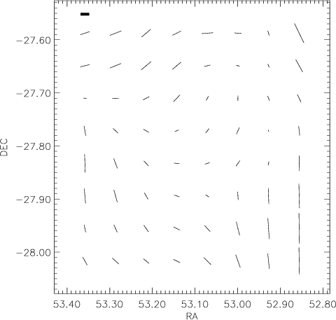 |
Figure 6: Vector representation of the PSF distortions for the final R-band image smoothed over a scale of 7 arcmin. RA and DEC are in degrees. The amplitude of the vectors are scaled relative to the thick line segment shown on the upper left corner, which corresponds to an amplitude of 0.0015. |
| Open with DEXTER | |
![\begin{table}
\par
\includegraphics[width=24cm,clip]{tab7.eps}\end{table}](/articles/aa/full/2001/44/aa1242/img67.gif) |
Source extraction was performed using the latest version of SExtractor software (Bertin & Arnouts 1996; ver. 2.2.1). This version resolves a subtle problem, first identified in the prompt release of the Pilot Survey, which caused the creation of regions devoid of sources when applying SExtractor to WFI frames with weights (Bertin 2001). Detection was carried out separately using the co-added image of each passband and field. The main parameters in the detection are the smoothing kernel, taken to be a Gaussian with a FWHM equal to 0.8 of that of the PSF measured on the frame; the minimum number of connected pixels above the detection threshold, depending on the seeing taken to be between 8 and 12 pixels, and the SExtractor detection threshold, taken to be between 0.55 (for U) and 0.7 (Rand I) depending on the seeing. As an illustration, the tabulation of the first 40 entries in the R-band source catalog is presented in Table 7. All magnitudes are given in the AB system. The table lists:
Column 1: the EIS identification name;
Columns 2 and 3: right ascension and declination (J2000.0);
Columns 4-9: total, isophotal and aperture (3 arcsec diameter)
magnitudes and respective errors. The first two magnitudes correspond
to the mag_auto and mag_iso magnitudes measured by
SExtractor. The magnitudes have been corrected for Galactic
extinction taken from Schlegel et al. (1998). The errors are those
estimated by SExtractor and include only the shot-noise of the
measured source and background counts. Only objects detected with
signal to noise ![]() (based on the isophotal magnitude errors)
are included.
(based on the isophotal magnitude errors)
are included.
Column 10: an estimate of the S/N of the detection, from the inverse of the errors estimated for the isophotal magnitude;
Columns 11: the isophotal area A of the object in square arcsec;
Column 12: the half-light radius ![]() in arcsec;
in arcsec;
Columns 13 and 14: minor to major-axis ratio and the position angle;
Column 15: the stellarity index computed by SExtractor;
Column 16: SExtractor flags (see Bertin 1998);
Column 17: EIS flags; these flags are used to identify objects
in regions with very low weight or close to bright objects. Objects
detected in regions with weight ![]() 30% of the maximum weight
(proportional to the total integration time) and not affected by
bright stars have EIS
30% of the maximum weight
(proportional to the total integration time) and not affected by
bright stars have EIS
![]() .
Objects with weight <30%, located
at the edges of the frame, have EIS
.
Objects with weight <30%, located
at the edges of the frame, have EIS
![]() .
Finally, EIS
.
Finally, EIS
![]() indicates that the object is located in a region masked out due to the
presence of a bright object.
indicates that the object is located in a region masked out due to the
presence of a bright object.
Similar tables for the other passbands are available upon request in
ASCII format. Catalogs for the infrared mosaic and optical/infrared
color catalogs will be distributed as soon as they become available.
Note that besides distributing catalogs in tabular form as done here,
catalogs in FITS formats will become part of the distribution of final
products. From the inspection of the R-band weight map (see
Fig. 3) one sees that, in contrast to catalogs
extracted from single chip detectors, describing source catalogs drawn
from multi-passband dithered observations of CCD mosaics requires
significantly more information than can reasonably be provided in a
single ASCII catalog. While the latter is adequate if the derived
objects list is to be used for optical cross-identification, it is
clearly not sufficient if one is interested in drawing statistical
samples with well-defined limiting magnitudes and color coverage. To
cope with these deficiencies, future releases will be made using FITS
tables which will include: a FITS header with all the relevant
information about the observations (pointing, filter, instrument), a
FIELDS table which will include: the SExtractor parameters; the
magnitude and stellarity index chosen for the star/galaxy
classification; magnitude corrections (e.g., AB, extinction) appropriate
for the filters used; a variety of limiting magnitudes (point source,
turnover, completeness, spurious objects) including the brightest
limiting magnitude to extract a homogeneous magnitude-limited sample;
the effective area corresponding to this sample taking into account
the area removed at the outer edges of the image based on the
weight-map and the masks around bright objects, both now being produced
automatically by the pipeline according to user-specified
parameters. At the same time, no objects will be removed but will carry
both their SExtractor and EIS flags, with the vertices of the
corresponding masks also being included in the FITS catalogs in a
specific fields table. This will also apply to color catalogs which,
in addition to information similar to single passband catalogs, must
also include others such as the definition of color context to clearly
indicate the area of intersection of images in different passbands. In
summary, the goal is to produce standard catalogs from which more
complex analysis can be carried out with or without the images and
associated weight maps.
The output of the new standardized procedures for single passband
catalog production is shown in Fig. 7 for the catalog
extracted from the final R-band image. The figure shows the outer
bounding box defined based on the percentage of the peak exposure time
one wants to consider and the masks around saturated or bright
objects. Both the magnitude of the objects to be masked and the size
of masks can be set by the user. In this example, one sees that not all
possibly spurious sources can be eliminated automatically. In
particular, in the lower right side of the figure (
![]() ,
,
![]() degrees) one sees the effect of a ghost image of a bright
star which produces a ring-shaped excess of objects. While attempts
are currently being made to identify ghosts and automatically
eliminate these regions, it is clear from the diversity of features
that in practice, further by-hand clipping of the image is required
depending on the specific application of the catalog. Tools for doing
so are also implemented in the pipeline with the results being stored
in the FITS catalog.
degrees) one sees the effect of a ghost image of a bright
star which produces a ring-shaped excess of objects. While attempts
are currently being made to identify ghosts and automatically
eliminate these regions, it is clear from the diversity of features
that in practice, further by-hand clipping of the image is required
depending on the specific application of the catalog. Tools for doing
so are also implemented in the pipeline with the results being stored
in the FITS catalog.
Each catalog produced by the pipeline goes through an automatic
verification process which carries out several tests to check the
reliability of the products by comparing them with other empirical
data and model predictions. The results of some of these tests are
described in the next section.
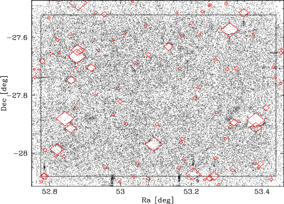 |
Figure 7: Projected distribution of galaxies extracted from the R-band image. The figure shows the adopted frame and the masks automatically produced by the pipeline around bright objects which are used to set the EIS flags. It is important to emphasize that these parameters can be re-defined. |
| Open with DEXTER | |
In order to externally verify the accuracy of the astrometric
calibration the source lists extracted from the different passbands
were compared with that available from the 2MASS survey (Cutri et al.
2000). The number of objects found in common ranges from 286 to 415
depending on the passband considered. Using "good'' objects,
considering the various flags, in both catalogs the relative positions
of coincident pairs were computed and the distribution of the
differences in the case of the R-band is shown in
Fig. 8. One finds an offset of about 0.12 arcsec
in right ascension, a negligible shift in declination and an rms in
the differences of
![]() 0.23 arcsec, independent of the passband
considered. This shows that the astrometric solutions for the
different passbands are essentially identical and an overall accuracy
of
0.23 arcsec, independent of the passband
considered. This shows that the astrometric solutions for the
different passbands are essentially identical and an overall accuracy
of ![]() 0.16 arcsec, probably limited to the internal accuracy of
the reference catalog, is achieved. Note that the shift of the optical
data relative to 2MASS is smaller than that obtained with the infrared
data. This, however, does not imply any inconsistency in the relative
astrometry of the infrared and optical EIS data but rather it reflects
the problem described in Vandame et al. (2001) with the astrometry of
the pre-release of GSC-II. This problem will be fixed with the
official release of the GSC-II.
0.16 arcsec, probably limited to the internal accuracy of
the reference catalog, is achieved. Note that the shift of the optical
data relative to 2MASS is smaller than that obtained with the infrared
data. This, however, does not imply any inconsistency in the relative
astrometry of the infrared and optical EIS data but rather it reflects
the problem described in Vandame et al. (2001) with the astrometry of
the pre-release of GSC-II. This problem will be fixed with the
official release of the GSC-II.
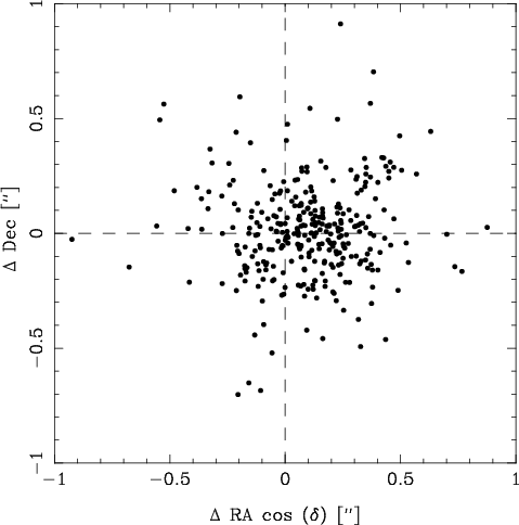 |
Figure 8: Comparison in the R-band between the coordinates of objects in common with the 2MASS survey, offsets are computed as EIS-2MASS. |
| Open with DEXTER | |
An independent check of the astrometry can also be carried out by
comparing the present astrometry with that determined by Wolf et al.
(2001; COMBO survey) who recently obtained deep exposures of the same
field in different passbands using the same instrument. In particular,
their R-band data reaches R=26.0 (Vega) at ![]() for a total
integration time of 23700 s. Within the overlapping area of both
surveys, there are:
for a total
integration time of 23700 s. Within the overlapping area of both
surveys, there are: ![]() 36800 objects in common;
36800 objects in common; ![]() 17500
detected only by COMBO;
17500
detected only by COMBO; ![]() 4400 only by EIS; and
4400 only by EIS; and ![]() 4200 have
multiple associations, which are not considered below.
Figure 9 shows the result of the comparison of the
positions for about 8500 objects in common. These objects include only
objects with stellarity index >0.9 in the COMBO R-band source list
and satisfying
4200 have
multiple associations, which are not considered below.
Figure 9 shows the result of the comparison of the
positions for about 8500 objects in common. These objects include only
objects with stellarity index >0.9 in the COMBO R-band source list
and satisfying
![]() mag and
mag and
![]() .
From this
comparison, one finds a relative offset of 0.15 arcsec in right
ascension and -0.24 arcsec in declination, but more importantly a
remarkably small rms of 0.12 arcsec in both directions, possibly
suggesting an accuracy of
.
From this
comparison, one finds a relative offset of 0.15 arcsec in right
ascension and -0.24 arcsec in declination, but more importantly a
remarkably small rms of 0.12 arcsec in both directions, possibly
suggesting an accuracy of
![]() 0.10 arcsec for each individual
catalog. This is well within the requirements for slit/fiber
positioning, a top requirement for the public survey. These results
are insensitive to the exact way the sample is chosen.
0.10 arcsec for each individual
catalog. This is well within the requirements for slit/fiber
positioning, a top requirement for the public survey. These results
are insensitive to the exact way the sample is chosen.
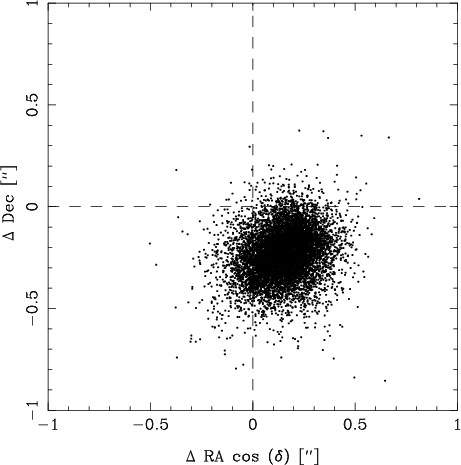 |
Figure 9: Comparison between the location of objects in common with the COMBO survey, offsets are computed as EIS-COMBO. |
| Open with DEXTER | |
The COMBO data also enables a comparison of the photometric
calibration. Figure 10 shows the results of this
comparison in the Vega system from which one finds a zero-point offset
of ![]() -0.01 with an rms of about 0.01 mag for
-0.01 with an rms of about 0.01 mag for
![]() mag, while for objects brighter than
mag, while for objects brighter than ![]() mag
saturation sets in. For magnitudes fainter than
mag
saturation sets in. For magnitudes fainter than ![]() the scatter
increases and beyond
the scatter
increases and beyond ![]() one sees the Malmquist bias effect.
one sees the Malmquist bias effect.
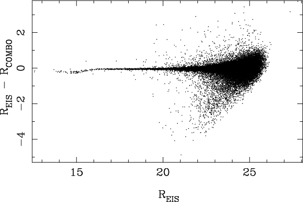 |
Figure 10:
Comparison between the measured R magnitudes of objects in
common with the COMBO survey as a function of the
|
| Open with DEXTER | |
![\begin{figure}
\par\mbox{\includegraphics[width=6.2cm,clip]{MS1242f11a.ps}\hspac...
...
\includegraphics[width=6.2cm,clip]{MS1242f11c.ps}\hspace*{7.5mm}}\end{figure}](/articles/aa/full/2001/44/aa1242/img86.gif) |
Figure 11: Comparison of stellar number counts in B (top panel), V(middle panel) and I (lower panel) passbands obtained from the present work (histogram) and those based on the Galactic model of Mendez & van Altena (1996; long-dashed line). In this plot, the magnitudes are in the Vega system. The model includes an old disk population (short dashed line), a thick-disk component (dot-dashed line) and a halo component (dot-dot-dashed line). |
| Open with DEXTER | |
A simple statistic that can be used to verify the overall characteristics of the derived catalogs and the parameters chosen for the star/galaxy classification is to compare the number counts of stars and galaxies with model predictions and other empirical data.
Figure 11 shows a comparison of the stellar counts as a function of the total magnitude (Vega system) with those obtained using the Galactic model described by Mendez & van Altena (1996), using the standard parameters described in their Table 1. Considering that no attempt has been made to choose model parameters to fit the observed counts, the agreement between observations and the model predictions is very good. In the B-band, where the present survey is deeper, there seems to be an excess of stellar objects. This is possibly due to QSOs, which are estimated to have a surface density of 120 objects per square degree per 0.5 mag interval at B=24(Hatziminaoglou et al. 2001). This effect is not expected in V and I because the surface density of QSOs at the magnitude where the stellar counts drop is expected to be small, of order 30-40 per square degree per 0.5 mag interval. Currently, the comparison of the star counts is only possible for the three passbands considered. However, this problem is being addressed and soon a more generic galactic model will be available in the EIS pipeline to compare the predicted counts in all passbands using the transmission curves for the filters being used in a given survey setup (Girardi 2001).
Similarly, Fig. 12 shows the comparison of galaxy counts as a function of the total magnitude, for each of the available passbands, with those obtained for other data sets. In this case, galaxies were defined as objects with a stellarity index less than 0.95 (0.90 in the I-band) or fainter than the classification limit of each passband. The sample includes only objects with S/N>3 and with the appropriate SExtractor and EIS flags and the normalization of the counts takes into account the effective area of each catalog. The U-band counts of Guhathakurta et al. (1990) and I-band counts of Postman et al. (1998) have been corrected assuming an AB correction of 0.8 and 0.45, respectively. As can be seen the observed counts are in good agreement with previously published results indicating that the catalogs being distributed are statistically consistent.
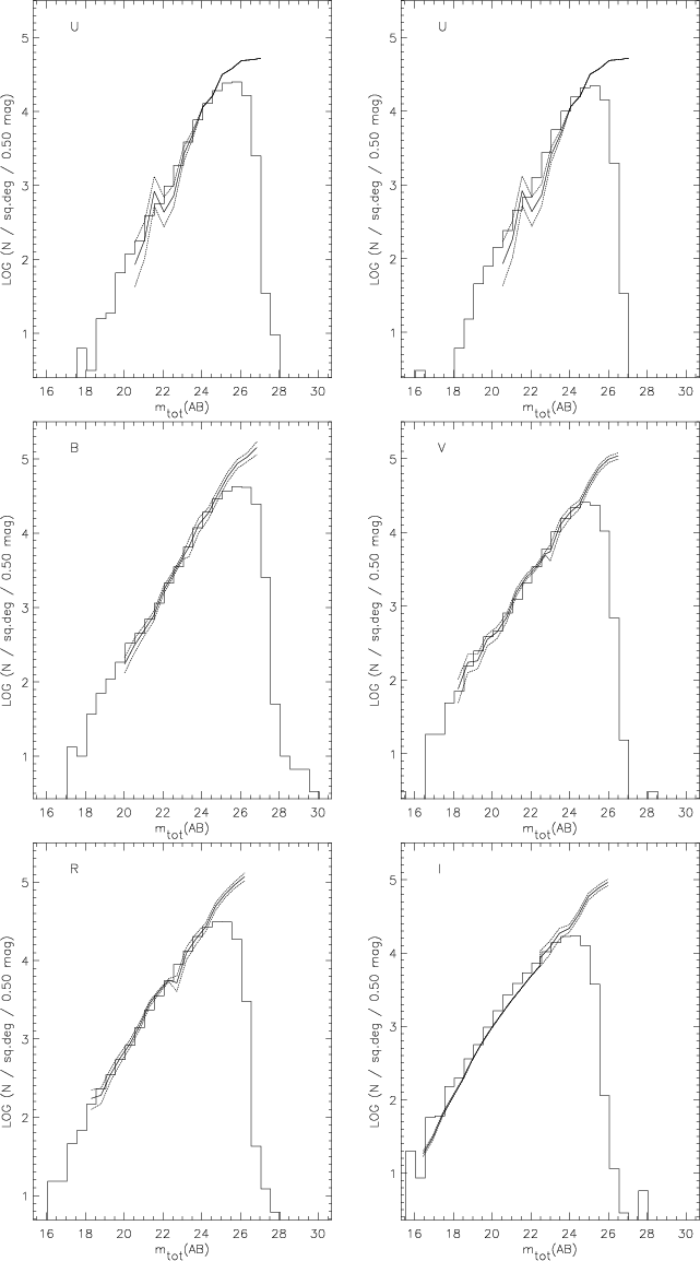 |
Figure 12:
Comparison of galaxy number counts from the present work
(histograms) with those from the following authors: U-band:
Guhathakurta et al. (1990); BVR-bands: Arnouts et al. (1997) and
Arnouts et al. (1999); I-band: Postman et al. (1998) and Arnouts et al.
(1999). The top left panel refers to |
| Open with DEXTER | |
The characteristics of the data obtained by the present survey are
summarized in Table 8 which lists: in Col. 1 the
filter; in Col. 2 the seeing of the final co-added image; in
Cols. 3 and 4 the ![]() and
and ![]() limiting ABmagnitude measured within an aperture
limiting ABmagnitude measured within an aperture
![]() ;
and in Col. 5
the number of objects with
;
and in Col. 5
the number of objects with
![]() ,
i.e. the number of entries in
the catalogs being distributed. At the
,
i.e. the number of entries in
the catalogs being distributed. At the ![]() limiting magnitudes
the fraction of spurious objects with
limiting magnitudes
the fraction of spurious objects with
![]() is estimated to be
is estimated to be
![]() 2% for all bands. The fraction of spurious objects was
estimated by creating catalogs from the survey images multiplied by
-1. The mock images were then used as input to the catalog
production and from the comparison between the catalogs of the mock
and real objects the fraction of false-positive detections was
estimated.
2% for all bands. The fraction of spurious objects was
estimated by creating catalogs from the survey images multiplied by
-1. The mock images were then used as input to the catalog
production and from the comparison between the catalogs of the mock
and real objects the fraction of false-positive detections was
estimated.
The fact that the COMBO data reaches fainter magnitudes can also be
used to obtain a first estimate of the completeness limit of the CDF-S
data in the R-band. Figure 13 shows the ratio as a
function of the
![]() of objects in both catalogs. From this
plot, one finds that the R-band catalog is complete to
of objects in both catalogs. From this
plot, one finds that the R-band catalog is complete to
![]() and 50% complete at
and 50% complete at
![]() .
This
estimate is probably conservative. A first indication is that there
are a large number of objects detected only in the data presented
here, most of them at the faint end
.
This
estimate is probably conservative. A first indication is that there
are a large number of objects detected only in the data presented
here, most of them at the faint end
![]() .
Second, the number
of spurious detections at
.
Second, the number
of spurious detections at ![]() is still relatively small
(
is still relatively small
(
![]() 30%). Clearly, a determination of the completeness of the
catalog from the CDF-S data themselves is highly desirable and will be
implemented in the near future.
30%). Clearly, a determination of the completeness of the
catalog from the CDF-S data themselves is highly desirable and will be
implemented in the near future.
| Filter | Seeing |
|
|
|
| (arcsec) | (mag) | (mag) | ||
| U | 0.98 | 25.7 | 26.3 | 37094 |
| U' | 1.06 | 26.0 | 26.6 | 42087 |
| B | 1.02 | 26.4 | 27.0 | 74827 |
| V | 0.97 | 25.4 | 26.0 | 45912 |
| R | 0.86 | 25.5 | 26.1 | 65148 |
| I | 0.93 | 24.7 | 25.3 | 43253 |
The limiting magnitudes reached by the present observations are, in
general, brighter than those originally proposed (
UAB=26.8;
BAB= 26.0; VAB= 26.0; RAB=26.3; IAB=26.0). For BVR, an
increase of the integration time by a factor of two is required to
reach the originally stated ![]() limits, representing a 50%
increase in the total integration time requested per pointing.
Certainly more serious is the requirements in U and I, even if
more efficient filters are used. From the present data, one finds that
the new U' filter has an efficiency at least 5% larger than the
original U. A similar increase in efficiency in I is possible
using a filter similar to the one available for EMMI for the EIS-WIDE
survey. However, even with the new filters the time required to reach
the desire magnitudes in U and I involve a large increase (a
factor
limits, representing a 50%
increase in the total integration time requested per pointing.
Certainly more serious is the requirements in U and I, even if
more efficient filters are used. From the present data, one finds that
the new U' filter has an efficiency at least 5% larger than the
original U. A similar increase in efficiency in I is possible
using a filter similar to the one available for EMMI for the EIS-WIDE
survey. However, even with the new filters the time required to reach
the desire magnitudes in U and I involve a large increase (a
factor
![]() 4) in their already long integration times. Such an
increase would make the desired area coverage unattainable. On the
other hand, the limiting magnitudes obtained by the present survey
compare favorably with those reached by EIS-DEEP from which
Lyman-break galaxy candidates drawn from those samples (da Costa et al.
1998; Rengelink et al. 1998) have been successfully confirmed
spectroscopically at
4) in their already long integration times. Such an
increase would make the desired area coverage unattainable. On the
other hand, the limiting magnitudes obtained by the present survey
compare favorably with those reached by EIS-DEEP from which
Lyman-break galaxy candidates drawn from those samples (da Costa et al.
1998; Rengelink et al. 1998) have been successfully confirmed
spectroscopically at
![]() (Cristiani et al. 2000), strongly
suggesting that the primary goal of the present survey is indeed
possible. A more detailed discussion of this point will be presented
elsewhere when attempts to combine the data obtained using the two
different U filters will be made (Arnouts et al. 2001; Benoist et al.
2001b).
(Cristiani et al. 2000), strongly
suggesting that the primary goal of the present survey is indeed
possible. A more detailed discussion of this point will be presented
elsewhere when attempts to combine the data obtained using the two
different U filters will be made (Arnouts et al. 2001; Benoist et al.
2001b).
Finally, as mentioned in Sect. 2, the CDF-S has already been observed both in optical and infrared passbands as part of the EIS-DEEP survey using the NTT (Rengelink et al. 1998). These old observations are being re-analyzed, using the new methods of the pipeline and compared with the present observations elsewhere (Benoist et al. 2001a). The infrared data from this survey is particularly important as it complements the infrared CDF-S survey recently completed (Vandame et al. 2001).
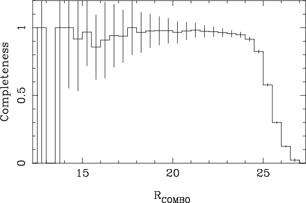 |
Figure 13:
Estimated completeness, and associated Poisson error, of the
CDF-S R-band catalog as a function of the
|
| Open with DEXTER | |
This paper presents the first optical results of the ongoing
multicolor Deep Public Survey being conducted by the EIS program. The
observations and the data for the first pointing completed as part of
this program which corresponds to the Chandra CDF-S field are
described. The set of products being publicly released includes fully
calibrated pixel maps and source lists covering the CDF-S
region. Given the current interest in this area of the sky both the
optical data presented here, covering ![]() 0.25 square degrees, and
the infrared survey recently released, covering an area of
0.25 square degrees, and
the infrared survey recently released, covering an area of ![]() 0.11
square degrees, are being made available world-wide. Hopefully, this
will, together with the Chandra X-ray data, contribute to making this
region of the sky a natural target for multi-wavelength observations
in the southern hemisphere and an ideal area for cosmological studies.
Other derived products from the EIS program will be described in
forthcoming papers in this series.
0.11
square degrees, are being made available world-wide. Hopefully, this
will, together with the Chandra X-ray data, contribute to making this
region of the sky a natural target for multi-wavelength observations
in the southern hemisphere and an ideal area for cosmological studies.
Other derived products from the EIS program will be described in
forthcoming papers in this series.
Acknowledgements
We thank all of those directly or indirectly involved in the EIS effort. Our special thanks to K. Meisenheimer and C. Wolf for making their U-band images and R-band catalogs available to EIS, E. Bertin for his quick response to our request for help, A. Bijaoui for allowing us to use tools developed by him and collaborators over the years and past EIS team members for building the foundations of this program. We would also like to thank A. Renzini and past and present members of the Working Group for Public Surveys. The Guide Star Catalogue-II is produced by the Space Telescope Science Institute in collaboration with the Osservatorio Astronomico di Torino. Space Telescope Science Institute is operated by the Association of Universities for Research in Astronomy, for the National Aeronautics and Space Administration under contract NAS5-26555. Additional support is provided by the Association of Universities for Research in Astronomy, the Italian Council for Research in Astronomy, European Southern Observatory, Space Telescope European Coordinating Facility, the International GEMINI project and the European Space Agency Astrophysics Division. This publication makes use of data products from the Two Micron All Sky Survey, which is a joint project of the University of Massachusetts and the Infrared Processing and Analysis Center/California Institute of Technology, funded by the National Aeronautics and Space Administration and the National Science Foundation. This research has made use of the SIMBAD database, operated at CDS, Strasbourg, France.