Each of the GPS satellites transmits on two L-band carrier
frequencies, L1 at 1575.42 MHz and L2 at 1227.60 MHz. A third
carrier, L3 at 1381.05 MHz, is not intended for GPS users. All of
these carriers are phase locked to harmonics of a fundamental, 5.115
MHz, oscillator. By measurement of the time delay between the
modulation on the L1 and L2 carriers, the ionospheric-induced delay
and hence an absolute measure of the total electron content (TEC)
along the line-of-sight to each visible satellite, i.e. the slant-TEC,
can be determined through the simple relation
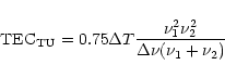 |
(1) |
The relative phases of the carriers can also be measured to obtain a
much more accurate determination of the TEC (the so-called phase-TEC)
via the relation
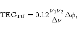 |
(2) |
Typically, our receivers would obtain data from six to nine satellites at any time, but some of these satellites were at such low elevations that their data were of little use for the correction of high elevation radio source observations. Therefore, useful data were normally obtained in about four to seven directions. Because the satellites are typically a radian or more from the astronomical source of interest, it is necessary to model the ionosphere using the GPS data and to then employ this model to estimate the TEC in the direction of the source.
Copyright ESO 2001